UNB researchers combine history and technology to create a new perspective on urban change.
Author: UNB Research
Posted on Nov 27, 2023
Category: Research
Two University of New Brunswick (UNB) researchers have teamed up to develop a novel approach to understanding 20th century urbanization.
By combining interdisciplinary research methods from social history and geomatics engineering, Dr. Sasha Mullally, a professor of historical studies, and Dr. Yun Zhang, a professor of geodesy and geomatics engineering, along with a team of researchers, are advancing a new way of looking at and understanding the spaces around us: Historical Geospatial Data Science.
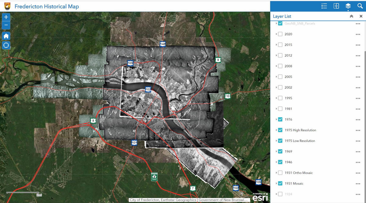
Using these techniques, the researchers have created and released a new way to explore the history of Fredericton, New Brunswick’s capital city, with the release of two more cities’ timelines planned for next year.
With funding through the federal New Frontiers in Research Fund – Exploration Grant program, they are exploring new ways to study history by combining archival photographs with current-day mapping technologies and innovative artificial intelligence (AI) techniques. They hope to deepen our understanding of historical changes to human settlement and to provide new opportunities for future research inquiry in related topics.
Scholars have embraced Historical Geographic Information Systems (H-GIS) with great enthusiasm in recent years, especially for research investigating urban development. These systems essentially add “time” as an additional dimension to three-dimensional geographical maps, allowing users to see the same space over a period of change.
Yet, the field has a data problem.
Vast archives of spatial information captured as aerial photographs and held in places like the National Aerial Photo Library (NAPL) in Ottawa cannot be efficiently used with existing GIS technologies. NAPL’s collection dates to the 1920s; however, while extensive, many photos are of varying quality, each capturing only a few hectares of topography at a time.
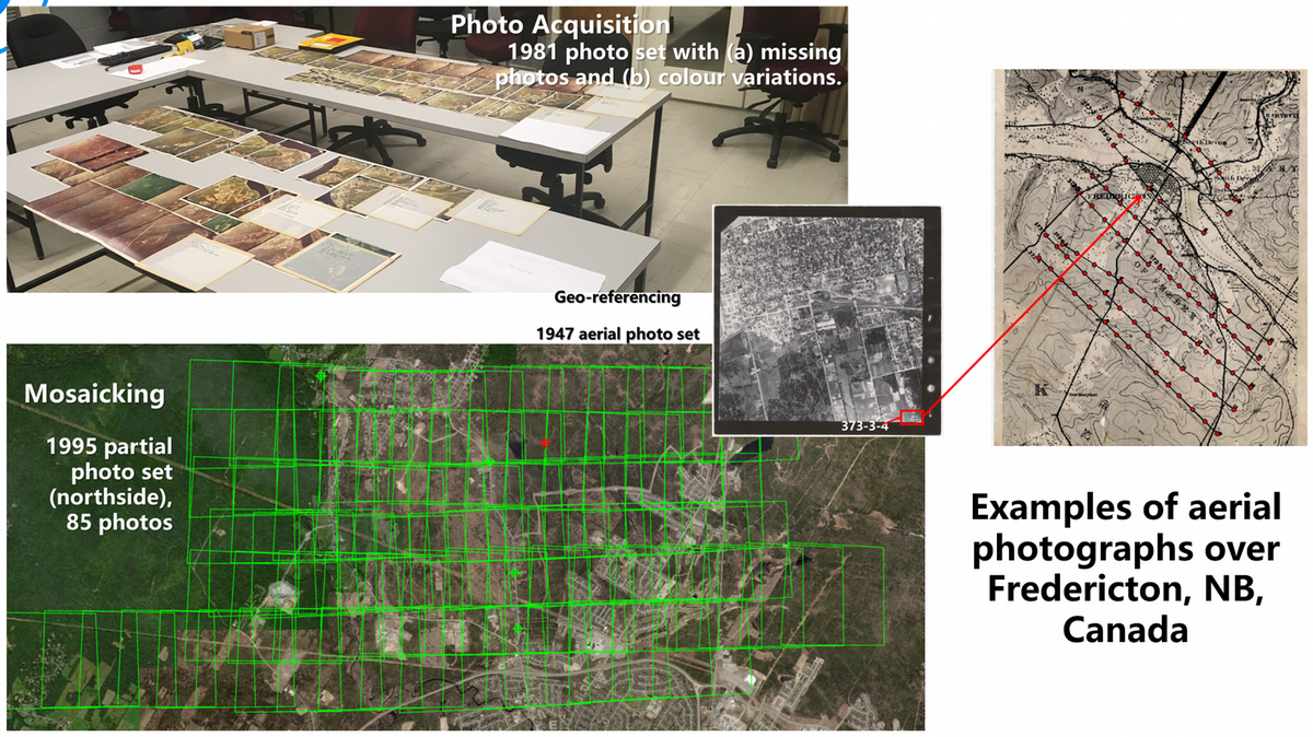 These must be painstakingly spliced together and georeferenced for accuracy to create a viable urban composite. Fredericton alone required a mosaic of close to 200 photos for a given year, a process that took months to complete. This limits researchers' ability to use them.
This new 3-City Time Series for New Brunswick (3CT NB) project uses modern geomatics and mapping technologies to develop a new semi-automated method for creating photograph mosaics of neighbourhoods, cities, regions and even whole provinces if server capacities allow. These visual materials can be organized to cover up to a century of topographical change. The researchers will also develop new Machine Learning (ML) and AI algorithms to interpret and analyze the change from a historical geospatial perspective.
The project focuses on New Brunswick, which, as many researchers have noted, provides a valuable case study of 20th-century urban and suburban development. Home to three cities of similar size – Fredericton, Moncton and Saint John – New Brunswick underwent significant social, political and economic changes in the 1960s, particularly with the Program for Equal Opportunity, launched by Louis J. Robichaud’s government in 1967.
 Combining multiple aerial photographs at a moment in time into a single "picture" of an urban space and creating a time series of one “picture” per decade, researchers may now see modern urban transformations, such as green space development, suburban expansion, and the impact of school zoning.
At the end of the project, the researchers will publish a century of aerial data for each city online. These will be accompanied by case studies that use research from municipal and provincial archives to explain observable trends in environmental change, housing development and government service expansion. Dr. Mullally and Zhang hope this resource will inspire other researchers to interpret other elements of this visual record and use these records to inform urban planning across Canada.
The Fredericton series is now available online, and will be further refined and updated as the project continues. The research team anticipate the addition of time series for Saint John and Moncton through 2024 and 2025.
More information
Dr. Sasha Mullally | Department of Historical Studies | Faculty of Arts (Fredericton)
Dr. Yun Zhang | Department of Geodesy and Geomatics Engineering | Faculty of Engineering
Research at UNB | Graduate Studies at UNB | Postdoctoral fellowships