Spotting whales from orbit: new research project will help protect endangered whales using satellite imaging
Author: UNB Research
Posted on Feb 12, 2021
Category: Research , Partnerships
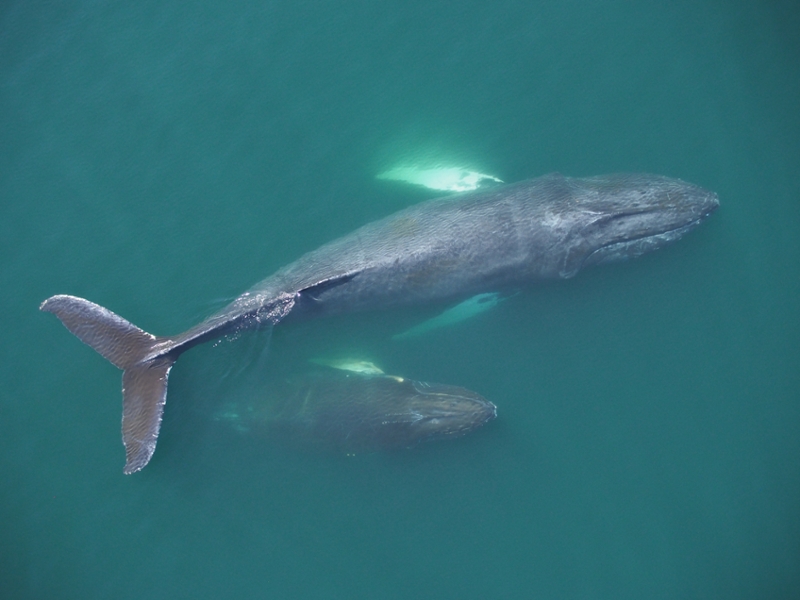
Image: UNB researchers captured this photo of two humpback whales in the Bay of Fundy during a research trip in 2020.
The federal government is investing $5.3 million into smartWhales, a research initiative that will use satellite technology to protect the endangered North Atlantic right whale. The initiative includes five projects funded by the Canadian Space Agency (CSA) and Fisheries and Oceans Canada, and has been organized with the additional collaboration of Transport Canada.
One of the five projects will develop new methods for detecting the whales using high-resolution satellite imagery. Two University of New Brunswick researchers, Dr. Kimberley Davies, assistant professor of biological sciences, and PhD student Gina Lonati, are working on this $1.2 million project.
The project is led by Hatfield Consultants Ltd, with additional partners at Dalhousie University, Duke University, the Canada Wildlife Federation and AltaML.
This intersectoral project brings together a wealth of expertise in research, conservation, technology and computer programming to explore the potential of satellite data in monitoring and predicting the movement of North Atlantic right whales.
“It is an interdisciplinary, international project and you need that in order to solve a problem of this magnitude,” said Dr. Davies. “We're really excited to be a part of this team,” said Dr. Davies.
North Atlantic right whales: a species at risk
North Atlantic right whales are an endangered species, with roughly 356 whales remaining in the world, and fewer than 100 breeding females. Collisions with ships and entanglement in fishing gear are the main causes of whale injury and death.
These animals are also difficult to locate at any given moment because of their small number and their mobility; airplanes and boats simply can’t cover enough water.
But because satellites can observe larger surface areas of the ocean, using them could improve large-scale detection.
The view from above: from drones to satellites
Ms. Lonati hopes her PhD research using aerial drones to image whales will help in developing an algorithm that can automatically detect whales in satellite images.
Ms. Lonati is currently using aerial drones to study the health of different species of whales in Atlantic Canada. She has been able to capture high-resolution images in visible (red-green-blue) and thermal (infrared) spectra. Combining the two images has helped Ms. Lonati learn about the body condition and temperature of the whales, as well as look for any entanglements or injuries.
Since satellite images are also captured from an aerial perspective, Ms. Lonati is hoping that the images from the drone can mimic those taken from a satellite. The partners of the project will then use these drone images to train a machine learning program to automatically detect whales from satellite images.
“It's a privilege to be able to contribute our data set to the larger goal of detecting right whales,” said Ms. Lonati. “The idea is that if the satellite identifies a right whale via imagery, we could alert the shipping industry or fishermen and help avoid entangling or injuring that whale in real time. We can also learn more about the whales themselves, including their habitats and movements, and where they are located at certain points in time.”
Ms. Lonati is looking forward to working with new equipment, cameras and sensors to add to the drone. She is also interested in working with multi spectral imaging, which will allow the researchers to see specific wavelengths of energy that can be detected by a satellite.
Bringing the right pieces together:
Dr. Davies’s lab will also be contributing data to the project from ongoing research with underwater gliders. The gliders are mobile autonomous underwater vehicles with microphones that listen for whale calls in real time.
The team will also be providing their expertise on the ecology of the whales and some of the challenges associated with detecting them on the surface in particular habitats and during different times of the year.
“These comprehensive datasets that we collect annually on the presence and distribution of the animals are incredibly useful as a calibration and validation data set for the satellite imagery and the satellite processing algorithms,” said Dr. Davies.
Dr. Davies also discussed some of the significant challenges in bringing this project together.
“For a long time, I think that there were people who said that it couldn't be done. As a discovery scientist, if someone tells me something can't be done, I am immediately motivated to figure out ways that it might be done,” said Dr. Davies.
One of the most important steps was getting the right people and the right expertise together.
“When we started to discuss it, it became evident that we can make advancements on this problem and satellites have been shown to work to varying degrees to detect other species and habitats around the world,” said Dr. Davies.
Ms. Lonati is also excited about the launch of the project, despite working from home with the pandemic.
“I think it’s so cool to know that the work I’m doing from my computer could inform some sort of management strategy that results in a whale being saved from entanglement or injury. In the end, it is important to find ways to balance the needs of the whales and the needs of the people, and to find innovative ideas to address these dynamic problems.”
Read more about the smartWhales initiative in our news release here, or the CSA's news release here.
Story written by Kesang Deker.