UNB gets Google Street View
Author: Communications
Posted on Sep 4, 2012
Category: UNB Fredericton
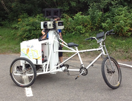
It's not every day you see a tricycle and an SUV with 360 degree cameras cruising around campus.
 But that’s exactly what happened on Sunday, August 19 when Google’s Street View crew visited UNB Fredericton.
The data collected by the Google crew on the 19th will help provide users of Google Maps with a street-level view of the Fredericton campus. This data will also help update the general details on Google Maps.
Having a street view of each of our campuses will help give a virtual tour that prospective students, parents and others can use to see just how great UNB's campuses in Fredericton and Saint John are.
Because UNB also uses Google Maps to power our campus map, this data will also be helpful for current students, faculty and staff.
And while Google wasn’t able to get down to the Saint John campus on this trip, they are planning on returning in late September to capture the campus.
Information Technology Services helped coordinate the visit with Google over the past few weeks. Google provides this service to universities and other organizations free of charge.
We're thrilled Google chose to visit UNB and look forward to seeing the street view of both UNB Fredericton and UNB Saint John. It's expected to take between six months and a year for the data to be made public and the maps to be updated.
Fun Facts:
- Google's Street view crew collects so much data they have to send complete hard drives back to California via courier for processing.
- Google captures the street view data using a collection of high-definition cameras and sensors that help create the 360 degree effect.
- The street view tricycle is non-motorized and weighs more than 100 kilograms, which makes going uphill a tad bit difficult at times.
- Google is experimenting with a camera set-up that can be worn by a person, further expanding the areas they can survey and include in maps.
- It takes so long for data to appear on Google Maps because Google blurs out individual faces and license plates of vehicles to help protect individual privacy.
- There are different Google crews for public area capture and privately owned land capture. Crews can spend weeks on the road capturing images before returning home for a break.