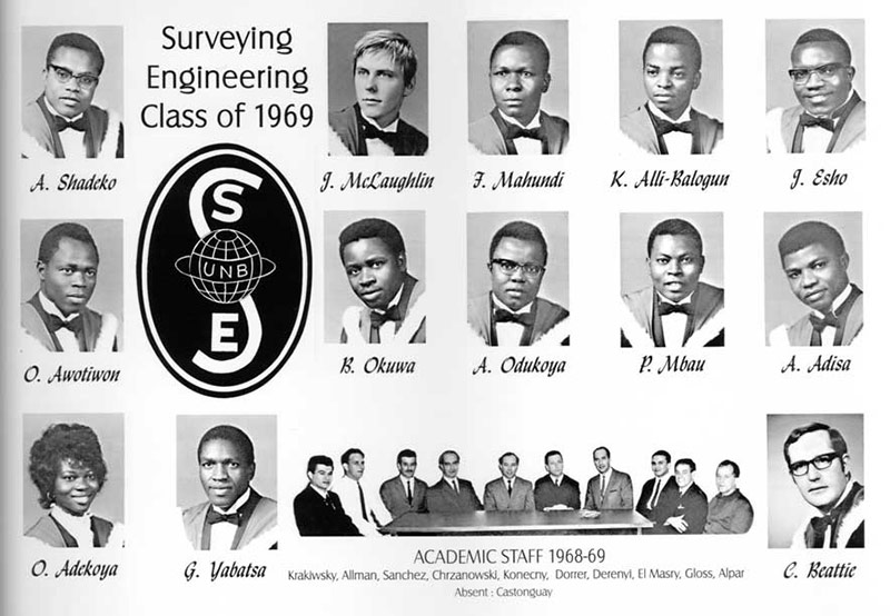
Alumni Spotlight: Clark Beattie
Author: Dylan Foote
Posted on Mar 15, 2021
Category:
Before joining the UNB Surveying Engineering (SE) program, Beattie was an undergraduate engineering student studying at Mount Allison. During this time Beattie was employed by the Geodetic Survey of Canada for two summers, where he travelled extensively and applied what he had learned thus far. In this role, Beattie was an “observer” in Northern Quebec, Ungava Peninsula, doing first order triangulation surveys. As an observer, Beattie explains he would use the “Tellurometer to measure long distances and a T3 theodolite for angles. So, I learned about precision measurements right from the start of my exposure to surveying.”
Two years prior to graduation, in 1967, Beattie worked on a project for the International Geophysical Year in the high Arctic. Here, Beattie and the team were based in Alert (Canadian Forces Station Alert | Royal Canadian Air Force) located on the north-eastern tip of Ellesmere Island in the Canadian Arctic Archipelago. Being only 817 kilometres from the geographic North Pole with a latitude of 82° 30’ N, Alert has very intense weather and working conditions. The team was tasked with creating a triangulation network across the Robson Channel between Ellesmere Island and Greenland. “We were told the purpose was to establish a precise network that could be used, when remeasured in future, to determine the rate of continental drift. Bear in mind that continental drift was a relatively new science at the time, so I was excited to be part of this expedition,” Beattie states.
During the same summer, the team moved to Nova Scotia where Beattie remembers they had “quite a different experience re-establishing an old network in majorly different conditions than Québec or Alert!” It was at this time when Beattie learned about the UNB Surveying Engineering program and decided to transfer from Mount Allison University to finish his engineering degree. (On January 1, 1994, the Surveying Engineering Department changed its name to Geodesy and Geomatics Engineering to better reflect the interdisciplinary spectrum of its activities.)
Beattie says, “when I graduated in 1969 our degree was a relatively new one that often required explanation that people politely accepted but rarely understood.” He adds that getting accepted within the niche professional engineering society imposed challenges and “was not automatic so in a sense we blazed the trail for those following.”
Beattie has had numerous exciting job opportunities and worked on many important projects. “I was put in management roles that enabled me to take leadership in modernization of methods and approaches to producing the data and information required to support organizational programs” Beattie recounts.
One example was the Land Registry Information System (LRIS) modernization of land records for the Maritimes. “It was exciting times because we were undertaking ambitious projects that established a geodetic control framework, implemented orthophoto mapping coverage, and developed techniques for property mapping that provided the foundation for change,” Beattie explains. The experience gained in those “early days stood me in good stead as I sought out opportunities to expand into other jurisdictions.”
In the late 1970s, Beattie moved to Alberta. Here, he introduced modern digital mapping techniques to the Alberta Government and eventually to the private sector where he worked for the remainder of his career.
In the 1990s, Beattie moved to Manitoba and helped established a private sector LRIS program that “was well ahead of its time,” he detailed. The company that was established back then is still operational and providing spatially enabled business solutions. The foundation provided by a surveying engineering degree “not only enabled me to take leadership of key areas but also to enable other graduates to work in the field.”
“One highlight of those years was the digital orthophoto program I implemented to provide accurate, current mapping data to the burgeoning geographic information systems (GIS) community as well as supporting the property mapping efforts of the provincial government.” Beattie adds he “pioneered the acquisition of aerial imagery using GPS and navigation systems that allowed us to produce one target map from a single pair of aerial photos thereby simplifying the map production process and overall quality of the product.”
Beattie continues explaining the “techniques seem antiquated in today’s technical environment but the key point is that with the background we had from surveying engineering, we weren’t shy about taking on new things and breaking the mold of how it’s always been done.” Doing so enabled Beattie to be recognized by others and to give consulting advice to people in various countries including Mexico, Guatemala, Peru, Chile, Kenya, Egypt, Russia, and the UAE. However, in addition to technical advice, there were the personal relationships Beattie built along the way, and still maintains to this day, Beattie affirms.
Later, and once again, Beattie’s SE background provided a natural progression into new technology. This time it was entering the GIS world. Beattie stated that his education gave him “the tools to help solve the spatial data issues being faced by the user community of the day.” At this time, major challenges were faced because of the limited ability to build, share, and maintain spatial databases. Beattie writes “this was limiting the adaptation of the technology and while less so today, getting access to reliable content is an important component of any GIS and today’s practitioners often overlook the fundamentals of subjects like GPS, coordinate transformation, mapping and surveying, etc. All the stuff that SE provides.”
The last six years of his career, Beattie “had the good fortune” to return the provincial government department where he worked 40 years earlier. Here, Beattie lead a multi-professional team that was tasked with developing, implementing, and supporting the geospatial information. Beattie notes “a lot had happened over those years but the foundation I laid down was still part of the issues we were solving all those years later. Consequently, the government people I interacted with and I, had a common understanding and desire to do the right thing.” In this role, Beattie was “able to bring a business-oriented approach as well as understanding the technical issues they faced and built a business plan that enabled them to build one of the most progressive and successful programs of delivering spatially enabled business solutions for their internal and external clients.”
Beattie says that a message within his story is that “while the academic part of SE provides the foundation, the social part of the experience can provide another foundation that not only benefits a career but also provides a network that lasts well beyond the work environment. Small class sizes and the specialized nature of the program are the catalyst but classmate relationships and connections with other people from other classes provide the fuel.”
Recalled by Beattie, his class consisted of 12 international students and three Canadian students. He adds that many international students went on to important roles in their native countries, “a testament to the value of the education they received.” After graduation, Beattie says we all dispersed, but I was fortunate to meet a couple of them along the way.” He met a classmate at a conference in Brazil — she went on to be Surveyor General of Nigeria. Another point in time in Kenya, his path crossed with another classmate and he had established a successful engineering company.
As Beattie mentioned, the student connections and friendships gained during your time in the department can last a lifetime. Beattie had the unique opportunity when “bumping” into a classmate, John McLaughlin, while flying back from Mexico. On the connection flight home, the classmates came up with the idea to have a 50th anniversary party, which was held in 2019.
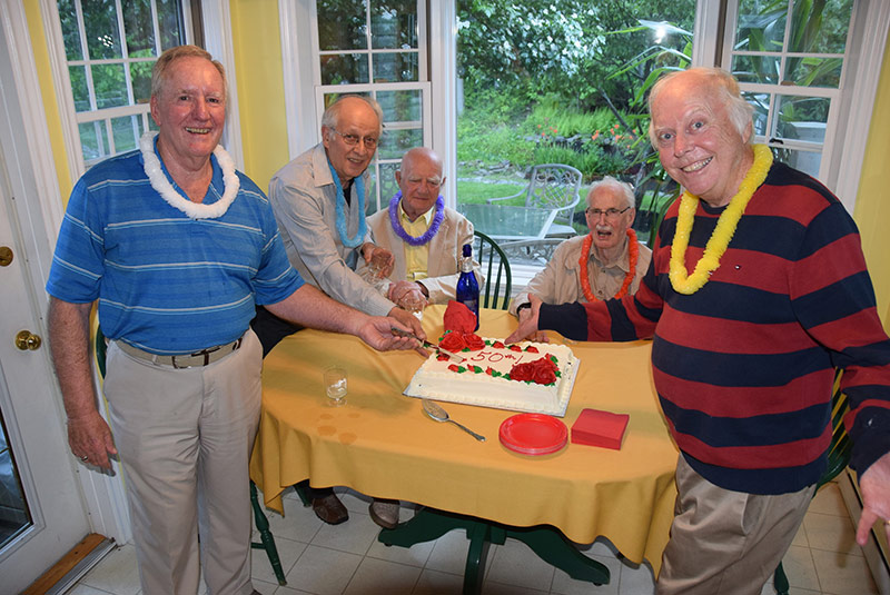
Left to right: Clark Beattie, Rejean Castonguay, Dr. Adam Chrzanowski (deceased), Angus Hamilton, Dr. John McLaughlin
Rejean Castonguay, was part of the Maritimes’ LRIS so “we were colleagues for a few years and crossed paths occasionally,” Beattie mentions.
Dr. McLaughlin went on to be a professor and the chair of the SE department and rose in UNB’s administration to eventually become the president of the university. Dr. McLaughlin and Beattie also “crossed professional paths over the years and were always somewhat in touch.”
Beattie explains “sadly, Adam (Dr. Chrzanowski) has since passed but it was nice to have the chance to interact with him that evening [of the party]. He was a model professor, extremely knowledgeable, world renowned and genuinely interested in his students.”
“Angus may be the most interesting with his books, farming and senior activities carrying on till now, I believe.”
Lastly, Beattie states the “SE background provided me the foundation I needed throughout my career of nearly five decades. I thoroughly enjoyed all the steps along my path and am supported by my wife/partner by my side. We got married a month after graduation and two weeks before starting my first job!”