EarthView3D Technology Is Changing Our View of the World
Author: Engineering Alumni Office
Posted on Aug 2, 2017
Category: Research Spotlight
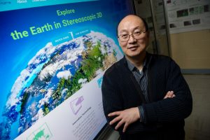
The next generation of online mapping is changing the way we see the world. EarthView3D, developed by Dr. Yun Zhang and his team in the department of geodesy and geomatics engineering, is unlike current mapping technologies, such as Google Maps. It allows users to see the heights of mountains and the depths of valleys in three dimensions. “Using our EarthView3D technology, civil engineers can more easily foresee where future roads should be built; the military will be better equipped to go into battle; developers can better plot real estate expansion; firefighters and search and rescue crews will have more insight before beginning their missions; and students will learn natural geography more effectively,” says Zhang, who holds the Canada Research Chair in advanced geomatics image processing at UNB.
Whereas Google Maps uses a labour-intensive method of stitching together photographs from aircraft to form a forced perspective that gives the viewer an illusion of seeing a building in three dimensions, EarthView3D uses patent-pending technology that generates stereoscopic satellite imagery drawn from publicly available satellite images, including those owned by NASA. The effect of seeing such a sharply detailed three-dimensional map is quite startling.
The project began in 2005 exploring different possibilities and potentials, and then stepped into technology and software development, a stage that took nearly three years to complete. Once the initial software was developed, the process moved quickly. For instance, it took only two weeks to create the entire three-dimensional map of Nepal. Zhang says that the reason Nepal was chosen from among all of the regions in the world is that in April 2015, Nepal was struck by a magnitude 8 earthquake that triggered an avalanche on Mount Everest. EarthView3D has the potential to be used as a useful technology to guide rescue workers through optimal routes in order to help earthquake and avalanche victims. In addition, Nepal is a small country that boasts a formidable mountain range, which includes Mount Everest and thus demonstrates the full range of and necessity for 3D technology.
Unlike other online maps, the satellite imagery captures both urban landscapes and natural landscapes in remarkable detail. It allows for global, regional and even neighborhood applications, meaning everything from measuring ocean depths to planning hiking routes in national parks to understanding street elevations when building.
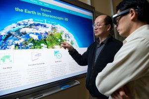
Zhang and his team, including key members David Fraser (BScEng’90, MScEng’99), a map technologist responsible for data processing, William Liu, a software specialist, and Marcel Dombrowski (MScCS’12, PhD’16) a hardware specialist, along with students when available, have been developing both the content and hardware needed to make EarthView3D available to everyone. Currently, there are three types of hardware that allow a viewer to appreciate the imagery: 1) Virtual Reality Headsets; 2) 3D projectors or 3D monitors; and 3) active shutter 3D glasses. “We are working with a company now, however, on developing a 3D case for use on any smartphone, so that anyone will be able to use EarthView3D whenever they’d like,” says Zhang. “This research area will continue to grow as the appeal of 3D technologies for everyday users is on the rise and 3D computers, televisions, smartphones and VR/AR devices will be more commonplace in the future. It is likely that more users will have access to necessary accessories – including the proper kinds of eyewear, screens, and software that will be compatible with EarthView3D. I want this technology to be usable for anyone who wants it.”
This isn’t the first groundbreaking technology Zhang and the team has discovered. In 2000, Zhang developed PanSharp – image fusion technology that results in high-resolution colour satellite photos – something Google requires for technology such as Google Earth. PanSharp was patented and a license sold to DigitalGlobe, the company that supplies Google with its images for the Google Earth platform.
EarthView3D is being developed at the Canada Research Chair in Advanced Geomatics Image Processing lab at UNB. “It’s really useful work that we do here,” gushes Zhang. So useful, in fact, that he finds it hard to maintain long-term student members on his team because the experience they are gaining through the lab makes it easy to find gainful employment elsewhere. The lab is an excellent training ground for students interested in learning about mapping and developing 3D software and hardware.
So where will Zhang take EarthView3D? He and his team are already demonstrating their cutting-edge technology to potential commercial partners including Google, Microsoft, and Apple. “Everyone says 3D is the future, and VR (Virtual Reality) is the future,” laughs Zhang. “But there is no future without content to view on these technologies. EarthView3D gives the content that will always be needed. Unlike movies and video games, maps are constant. There is huge potential here.”